
Editor’s Note: The original article from Disclosure News Italia included videos showing the manipulation of Hurricane Dorian, but were blocked from being shown. These placement of missing videos are noted in the article below.
The timing of this storm is interesting. My thought is “weather warfare” used by the Deep to terrify humanity (Current Hurricane Dorian included) is now being tempered by positive actions of the Light and perhaps being used as a kind of “cover operation” for unknown actions being taken against the Dark.
So…here in coastal NC (I have relocated home) we are at the ready with generator fired up, gas cans filled, food purchased, and blow-able items stored. (I don’t think we will need these, but…)Please read the article below, know that all things (including the weather) are under control of the Light, and BE…
InJoy!
___________________________________________________________________________________________
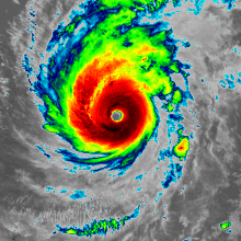
Hurricane Dorian Manipulation. By paulmuaddib61.
I noticed something with Hurricane Dorian i have seen beforricanere.
On February 22 Typhoon Wutip was held in place for almost three days for a secret military exercise over Guam.

Clicks on the Ads Keep Us Alive
Typhoon Wutip
Typhoon Wutip during an eyewall replacement cycle
Typhoon Wutip, known in the Philippines as Tropical Depression Betty, was the most powerful February typhoon on record, surpassing Typhoon Higos of 2015. Wutip originated from a low-pressure area on February 16, 2019. The disturbance moved westward, passing just south of the Federated States of Micronesia, before later organizing into Tropical Depression on February 18, 2019.
On February 20, 2019, the tropical depression intensified into a tropical storm and was named Wutip, before strengthening further into a typhoon on the next day. Wutip underwent rapid intensification, and on February 23 Wutip reached its initial peak intensity, with 1-minute sustained winds of 250 km/h, and a minimal pressure of 925 millibars while passing to the southwest of Guam.
Wutip underwent an eyewall replacement cycle shortly afterward, which caused the storm to weaken as it turned to the northwest. Wutip finished its eyewall replacement cycle on February 24, which allowed Wutip to restrengthen, with the typhoon rapidly intensifying once again.
On February 25, Wutip reached its peak intensity with 10-minute sustained winds of 195 km/h, 1-minute sustained winds of 260 km/h, and a minimum central pressure of 920 millibars, becoming the first Category 5-equivalent super typhoon recorded in the month of February.
Afterward, Wutip weakened on February 26, due to encountering strong wind shear. Wutip rapidly weakened as it moved northwestward, before dissipating on March 2. Hurricane Dorian Manipulation

They held it in place with a high pressure ridge then blew it out.
BLOCKED VIDEO


Same thing is going on here.
Extremely strong ridge over the United States taking the full force of the front of Hurricane Dorian and surrounded it on the other sides by high pressures.
BLOCKED VIDEO
And a new one today spreading out and protecting the entire East Coast.
BLOCKED VIDEO

Well, look what we have here. guess now we know what started that high pressure ridge heading towards the coast and is blocking Dorian. I was only able to grab a screen shot.

Clicks on the Ads Keep Us Alive

Creativity
I’m always thinking about creating. My future starts when I wake up every morning… Every day I find something creative to do with my life.
Miles Davis
