__________________________________________________________________________________________________________
AccuWeather meteorologists warn an expansive snowstorm is set to unfold across parts of the center of the country before the end of the week and jeopardize holiday travel plans ahead of the Christmas weekend.
The timing of this cross-country winter storm could not be worse, as millions rush to finish their shopping or embark on their holiday travels. During the period from Dec. 23 to Jan. 2, 112.7 million people are expected to travel more than 50 miles from home, according to the American Automobile Association (AAA).
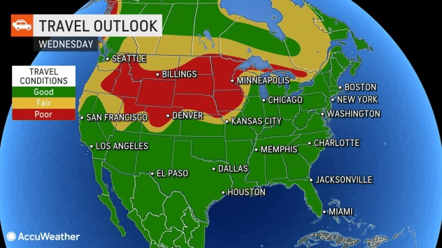
The storm first began to bring wintry weather across the Northwest Monday night, with snow falling in cities like Seattle and Spokane, Washington. As it moves eastward, the storm will become more potent into Wednesday, with the worst of the travel delays centering on major hubs like Denver and Minneapolis. Ripple-effect delays from affected aircraft and crews will start to be felt across the nation, even in areas not yet impacted by the storm.
The strengthening storm will emerge from the Rockies Wednesday and Wednesday night. Snow will first begin across the Dakotas, Minnesota and Nebraska before it spreadssouthward. Accumulating snow could fall as far south as Colorado and Kansas before sunrise Thursday morning.

Ahead of the storm’s arrival, winter storm watches were issued across almost a dozen states in the Plains and Midwest, including in Kansas City and St. Louis on northward to Chicago and Minneapolis.
The snow will continue to translate from the Plains into the Great Lakes and Ohio Valley into Thursday. Just north and west of the storm’s track, there is the potential for 6-12 inches of snow which AccuWeather meteorologists believe will stretch from northeastern Kansas into Michigan. Higher snow amounts, with the potential for an AccuWeather Local StormMax™ of 48,” are likely downwind of the Great Lakes.

Snow is expected to pile up on major highways like portions of interstates 55, 70, 80 and 90 and can lead to slick or slowed travel. Any areas left untreated, from highways to sidewalks, are likely to turn icy quickly.
The quick intensification of this storm across the center of the country during the week will bring noteworthy impacts, even outside of the snow. The storm will undergo a process called bombogenesis, which is when a storm (low pressure area) undergoes rapid strengthening and allows the barometric pressure of the storm to fall at least 0.71 of an inch (24 millibars) in 24 hours.
As the pressure plummets, winds will rush in and swirl at high speeds around the storm’s center.

“Strong winds are expected on the back side of the storm, bringing gusts in excess of 40 mph from the northern Plains all the way to the Texas Gulf Coast,” said AccuWeather Meteorologist Jake Sojda. Pockets of even stronger winds up to 70 or 80 mph are possible from northern Texas into the Great Lakes by week’s end,forecasters say.
The result of both snow and wind will be nothing short of blizzard conditions in many Midwestern states including Illinois, Indiana, Michigan, Wisconsin, Iowa, Kansas, Nebraska and Missouri. A blizzard is officially defined by the National Weather Service as blowing and/or falling snow with winds of at least 35 mph that reduce the visibility to a quarter of a mile or less for at least three hours.

“Even after the worst of the precipitation and wind has ended, the storm’s impacts will linger across the region,” explained Sojda.
Frigid air, ongoing gusty winds, blowing and drifting snow and hard-packed snow and ice on the roads will continue to make for horrendous travel conditions on Christmas Eve and perhaps into Christmas Day across much of the Midwest.

High winds and temperatures plummeting into the 20s, teens and single digits Fahrenheit during the storm can result in life-threatening conditions for motorists who become stranded on highways in the Midwest. AccuWeather RealFeel® Temperatures during and after the storm in the snow zone will drop well below zero.
Locations to the south of the worst of the storm’s wintry precipitation should still brace for icy conditions, AccuWeather meteorologists warn.
“Precipitation in cites like Little Rock, Arkansas, Nashville and Atlanta is expected to start off as rain, but the sudden and extreme drop in temperature could still lead icy conditions,” explained Sojda.

The intrusion of cold air could switch rain over to snow in some locations and allow for any wet areas to turn slippery.
A rapid freeze-up can make travel difficult and dangerous across a large stretch of Interstate 40 and perhaps as far south as portions of I-20 in the South Central and Southeastern states, there will be a small amount of snow and/or sleet that can briefly melt and freeze on roads as the Arctic air sweeps in from Wednesday night to Friday.
The patchy snow and ice could develop across a large area and cover portions of Oklahoma, Arkansas, Tennessee and Kentucky. The wintry weather will also extend into the northern portions of Mississippi, Alabama, Georgia and the western portions of North Carolina and Virginia.
AccuWeather’s team of more than 100 meteorologists will continue to provide updates on the storm and the outbreak of Arctic air through this week and into the Christmas weekend.
